| Accommodation
|
What's On?
|
Travel
|
Webcams
Classified Ads | Local News | Photo Gallery | History Galway Arts Festival 2004 |
Salthill Airshow A Red Arrows Hawk aircraft pulls up from a dive during at the Salthill Airshow. Sunday 6 July 2003. Photo: Joe Desbonnet.
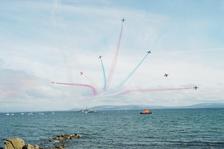 The Vixen Break at the end of the Red Arrows display. In the background is LE Ciara (Irish Naval Service) and the Clare mountains in the distance. Photo: Joe Desbonnet
Around Galway A labrador watches the sunset at Salthill, Sunday 6 April 2003. Photo: Joe Desbonnet
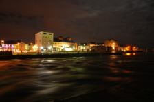 Claddagh at night. Photo: Joe Desbonnet
|
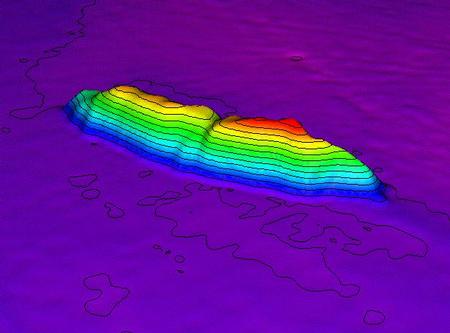
seabed_surveySeabed Survey Provides Rich Outline of Potential ResourcesThe deep-water section of the largest marine survey ever undertaken anywhere in the world has just been completed off Ireland. The EUR32 million National Seabed Survey will provide maps and information which will be of major importance for Ireland, both commercially and scientifically. So far, 450,000 sq kms of the seabed off our coast has been surveyed, providing data which will be of crucial interest to fishermen, exploration companies, and marine scientists among others. The full survey will take seven years to complete and so far is on time.
Following three years of work, a milestone was passed this week with the presentation to the Geological Survey of Ireland (GSI) of the report covering an area of the Irish seabed more than five times the land area of Ireland. The report was presented to GSI by Noel Hanley CEO, GOTECH, an Irish company that was successful in the international tender process for this portion of the survey. The survey, being managed by the GSI, is funded by the Government. When finally concluded, it will map most of Ireland's offshore seabed area - one that is 10 times that of our land area. Junior Minister at the Department of Communications, Marine and Natural Resources, John Browne TD declared: "We are near the half way stage and everyone involved in the project is very excited about the wealth of knowledge we are learning about the seabed around our coast. Remember, this survey in a sense maps out our future, providing us with vital information which could be of major benefit to Ireland, both from a commercial point of view but also scientifically." The Minister went on: "Most of Ireland's seabed is unmapped and consequently represents a large untapped resource of potential benefit to many different sectors. In authorising this survey, the Government recognised that Ireland must maximise the commercial opportunities presented by its marine resources and plan measures to protect the marine environment in the most effective manner possible." "In simple terms the survey will tell us about the outcrops, the corals, the very face of the seabed and the type of material and rock which constitute it. This will be of tremendous benefit to fishermen, exploration companies and even telecommunication firms who may be planning to lay cables and need to know the outline of the seabed. No other country in the world has attempted such a major project," the Minister added. Dr. Peadar McArdle, Director, GSI, declared: "We have come a long way from the modest origins in the 1970s when GSI employees used to dive from small craft to take samples close to shore and hang hydrophones over the side, to the current use of highest international standard state-of-the-art technology. Great credit is due to the Government to have the foresight to fund this valuable project." In July 2000, the first vessels took to the water as surveying began in the deep-water portion, Zone 3 (areas of water depth 200-4,500m). Since then the vast seabed off the west coast has been thoroughly investigated as never before to reveal massive valleys, canyons and substantial rocky outcrops on an impressive scale. The information being gathered includes the composition of the rock and sediments forming the seabed as well as underlying structures. Detailed studies of over 450,000 square kilometres of the seabed in Zone 3 have now been completed, and data is available both digitally and in paper form from the GSI. By August 2002, six ships and one aircraft had been employed in carrying out the survey. One of those ships - the Marine Institute's Celtic Voyager - has commenced work in Zone 2 (50-200m depth) concentrating on Donegal Bay. A pilot study utilising an airborne laser was carried out over Clew Bay off Co Mayo by the Australian Tenix LADS company to bring another dimension to the survey in Zone 1 (0-50m depth). Vessels of opportunity such as the Russian research ships 'S/V Professor Logachev' and the 'A/B Akademik Boris Petrov' have been used to obtain video footage of deep-water corals discovered off the west coast and to haul up numerous grab samples from the seabed. All are now being investigated as part of the ongoing data-processing system. Mick Geoghegan, Project Manager of the National Seabed Survey, GSI confirmed that the National Seabed Survey is on schedule and he commended the various partner organisations involved in the survey including the Marine Institute. He stated: "The anomaly of the vast majority of the Irish seabed being unmapped has now finally been addressed. The results will provide key benefits for many facets of Irish life. These maps are a pre-requisite for the policy evolution, management and sustainable development of Ireland's marine resources. Maps can be customised for specific uses by policy makers, engineers, biologists, oceanographers, geologists and seafarers and others." A book detailing the origins, achievements and benefits of the National Seabed Survey will be published in autumn 2003. Releated Links
|