Chapter 6: Inis Uí Chuinn to Inis A' Ghaill and Cunga Fheichín (Cong)
- Islands of Loch Coirib
- Shrule
- Ballycurrin House
- Inchagoill
- Inís mhic a'trír
- Cross Castle
- Ancient Churches of Cill Fraocháin
- Moytura
- [?? no title yet]
Return to table of contents
Refer to Map
Continuing our route on to the village of Cong, through the great cairn-studded plain of Moytura, we meet another small ancient church called Cill Ársa, in the townland of Ballymagibbon, of which twelve feet high of the east gable, with a small, round arched window in it, still remains, as shown in the accompanying cut; as also so much of the side walls as to give the measurement of its interior as twenty- four feet long by sixteen and a half feet broad.[fn77-1] Again, a little nearer the lake, in the village of Gort a' churra, "the field of the currach" (scrub or bottom), there formerly existed the ruins of a very small church, some of the large stones of which may still be discerned in the adjoining walls and cottages.

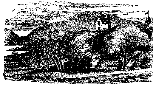
From the hill of Tonlegee, overlooking this latter locality, was taken the accompanying view of Moytura House, the residence of the Author, erected in 1865; and so called after the ancient battle-field on which it stands, with Benlevi Mountain in the distance, and Loch Coirib in front. The tower with the flagstaff stands within the enclosure of one of the ancient cathairs of the battle field. This house commands a magnificent prospect to the west, south, and east, and can be seen from most parts of the middle lake. To the west of Moytura is Leaca Fionna--"white flagstones"--the residence of Ormsby Elwood, Esq.; and still nearer to Cong, over a small bay of the lake, stands Lios Luachra--"the rushy liss," or earthen fort--the residence of William Burke, Esq.
We have passed the last navigation mark, and laid our course nearly due north towards the Cong river. From this point the mountain view presents one of its best aspects, and the shores of Mayo and Galway, sloping down to the water's edge, are in many places pleasingly wooded.Leaving Coad Island on the left, we get among a group of islets at the mouth of the river, the outermost of which, Oileán Rí, or "the king's island," was said to have been a favourite retreat of O'Conor, the last Irish monarch, while sojourning in the neighbouring abbey; and nearer the shore are Inis Cunga and Oileán Dara.
Now, dividing the waters of Mayo and Galway, we pass Ceann a'Doire "the head of the oakwood," and enter the principal streamway which conducts the aters of Loch Mask into Loch Coirib. Well sheltered, wooded on both sides, having Kinlough on the right, the demesne of Ashford on the left, and Strandhill, the sea of the Elwoods, in front, with the pretty spire of the parish church in the distance, it forms a picture of great beauty. The following illustration, taken from the eastern shore, represents the "Eglinton" passing under the demesne of Ashford, the noble seat of Sir B. L. Guinness, M.P., with its tower rising over the surrounding woods.

Our steamer has been warped around the little island, and brought to her berth alongside the quay. We leaver her for the present; and starting for "The Carlisle Arms," in the vollage about half a mile distant, may visit two of the natural caves for which this locality is celebrated -- The Lady's Buttery and the Horse Discovery, which both adjoin the road. Here, as we pass along by the canal referred to at page 3ced-p35 , we get a good view of the parish church, the Roman Catholic chapel, and the eastern gable and window of the abbey, which with the history and antiquities of this ancient locality, will be described in the next chapter.