Connemara International Marathon 2005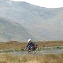 Interest in the Connemarathon has exploded since its humble beginnings in 2002. It will be held over the weekend of 26th and 27th of March 2005. Go on! Put the Connemara International Marathon in your calendar now. Photo by Joe O'Shaughnessy
Book your place today!
Interest in the Connemarathon has exploded since its humble beginnings in 2002. It will be held over the weekend of 26th and 27th of March 2005. Go on! Put the Connemara International Marathon in your calendar now. Photo by Joe O'Shaughnessy
Book your place today!
A Windy Day in Connemara
Flowers of Connemara
Kylemore Abbey Connemara
|
DrivesDrives
The Sky Road Drive
The Sky Road, Clifden - An Exhilarating DriveThe Sky Road is an exhilarating 11km/7ml circular drive west of Clifden. Leave Clifden passing the Abbeyglen Castle Hotel (on your left). About 400 m beyond this hotel look back towards Clifden. The 12 Bens provide a wonderful backdrop to the town and along with the two church spires, they give Clifden its distinctive skyline. Further along the road is a gateway leading to leading to the ruins of the old D'Arcy mansion, Clifden Castle. These ruins over look the sea and can be reached by going on a ten-minute walk down a farm track, near the Sky Road. Once a Gothic Mansion, the D'Arcy's lived here until 1850 when the estate was sold to the Eyre Family who lived here at intervals until the castle fell into ruin in the early 20th century. A little further along, the road separates to the left you can take the low road by the sea, but it is recommended to continue along the high road where the road climbs to a height of over 500ft. Along the high road you will pass the ruins of the old coastguard station on your left). As the road rises there are breathtaking views of the islands (Inishturk and Turbot), and the surrounding coastline. At the summit of the Sky Road peninsula there is a car park. Leaving the car park the road descends for a further 21/2 km where it meets the low road. Nearby are lovely beaches. Continuing along for another 2kms there is a road off to the left, which is about 2km long and ends at Eyrephort the edge of the Atlantic. Returning to the Sky Road again, you continue for a further 3km along the edge of Streamstown Bay, where there is a green Connemara Marble quarry. Eventually you will join up with the Clifden/Westport N59 Road. Back to topCoast Road - Heart Of the GaeltachtTo drive along Galway's coast road is to feel life's difficulties slipping away. On the left is the powerful Atlantic while to the right is the rocky landscape of Connemara. On sunny days the beaches along this road are filled with families, and nothing is more refreshing than a swim in the ocean. Fresh water and sea fishing are abundant, and there is a range of watersports for those who want an active break. If you just want to take life easy you can do that too. The pace of life here is relaxed and people are hospitable. Much of the area is Irish speaking and many old customs survive. Towns and Villages Along the Coast Road.An Bearna (Barna)This is a pretty village 5 miles west of Galway, which has small fields to the right, and to the left Galway Bay stretching out into the Atlantic. There is an attractive well sheltered beach here between Salthill and Barna at Silver Strand. Na Forbacha (Furbo)There is a very fine sandy beach and coves along the coast. When Udaras na Gaeltachta, the semi-state body for promoting industry in the Gaeltacht areas was decentralised from Dublin in 1969, it established its head office here. An Spideal (Spiddal)There word Spideal comes from 'ospideal' meaning hospital. There may have been a leper hospital in the area at one time. Built on the edge of the Atlantic, the town has beautiful scenery. It was once an exclusive bathing spot for the gentry and their ladies, who came in from their Connemara estates during the Summer. It is now a homing place for poets, painters and sculptors. Its location in the heart of the Connemara Gaeltacht makes it a haven for huindreds of Students every Summer, who go there to leran Irish. It has beautiful beaches for water enthusiasts. Despite its close proximity to the city it still retains some elements of traditional life. Indreabhan (Inverin)The new Connemara airport is situated here and it is also the base of Aer Arann who operate daily flights to the Aran Islands. Ros an Mhil (Rossaveal)Rossaveal is a small fishing village where much of today's catch is processed and exported by the large fish companies who are based here. Here is also the departure point for Island Ferries which serves the Aran Islands An Ceathru Rua (Carraroe)Thirty miles west of Galway city, is a vibrant Gaeltacht area. Carraroe is a lively town, with beautiful beaches including the coral strand. Preched on a peninsula on the Atlantic edge, it has breathtaking scenery. Casla (Costello)The village of Costello is on the main Galway Carraroe road. It's irish name 'Casla' means sea inlet. This village is the National headquarters for Radio na Gaeltachta and TG4, the state sponsored Irish speaking radio and TV service, established in 1972. It was to Costello that J. Bruce Ismay, Chairman and Managing Director of the White Star Line, which owned the Titanic, came after the liner sank in 1912. Leitir Moir (Lettermore)The village of Lettermore is situated on an island of the same name, one of a number of islands connecting to the mainland by a series of bridges. The landscape is a rocky one punctuated by small lakes. In the days of the Penal Laws, Lettermore was garrisoned and a law was passed restricting the freedom of the monks and the priests. There are remains of several churches and holy wells locally. Back to topThe Great Figure Eight Full Day TourGalway - Oughterard - Maam Cross - Clifden - Letterfrack - Kylemore - Leenane - Maam - Screeb - Casla - Spiddal - Bearna - Galway.Take the N59 road to Moycullen village, and onto the town of Oughterard. On route turn off at the sign for Aughnaure Castle and visit a 16th Century tower house in a very picturesque setting. After Oughterard the fertile land fed by the River Corrib and it's many lakes gives way to the dramatic rugged landscape of Connemara. Return to the N59 and continue to Maam Cross where roadside fairs are still held regularly. Pull into Peacockes hotel and avail of the 20m high tower for a panoramic view of the surrounding country. Go straight through the crossroads towards Clifden, pausing to admire the stunning scenery around Derryclare Lough, and perhaps dropping into Dan O'Hara's Homestead and visitors centre. Clifden is a pretty coastal town to stroll around and why not stop and shop at the station house complex, a railway terminus converted into an attractive shopping precinct. Not to be missed is the 7ml/11km drive along the Sky road for some breathtaking views. Back onto the N59 and head for Letterfrack, a village founded by the Quakers. In the vicinity is the Connemara National Park, which is well worth a half or full day's visit for its beautiful walks and excellent interpretation centre illustrating all the flora and fauna to be seen. Continuing on you pass Kylemore Abbey and Gardens, once the home of wealthy Victorians now a private school run by nuns, but is open to the public all year round. Next stop is the tiny village of Leenane nestling at the foot of the majesty Maamturk Mountains, at the tip of Killary Harbour - Irelands only fjord. The was the setting for the film 'The Field' starring Richard Harris, as attested by proudly displayed photos in a local pub. The cultural centre provides interesting information and nearby is Nancy's Point from where cruises depart for regular trips to Killary Harbour. Turning right at the village onto the R336 one journeys into Joyce Country, so called because of the importance of the Joyce Family to the region (but not to be confused with Dublin's James Joyce). You have also entered the area of An Ghealtacht, where Irish is the first language, and so are most of the road signs. Continue on through Maam and at Maam Cross (Peacockes Hotel) drive straight on towards Screeb, passing Casla and heading towards the coast. Note how radically the scenery has changed, from mountainous regions to lush fertile lands and wooded hills dotted with small lakes, to barren stony fields where generations of peasants cleared the land and built the dry stone walls that marked their meagre holdings. This drive takes visitors on a truly impressive diversity of landscapes. The last leg of the journey takes us on the R336 along the coast road through Inverin, Spiddal and Bearna - where the Gealtacht area officially ends. To your right Galway Bay offers beautiful views across to the Burren in Co. Clare on the far shore, as you head back towards Galway City. Back to topLough Inagh Drive (164km.102mls)Clifden - Ballyconneely - Roundstone - Toombeola - Derryclare lough - Inagh Valley - Cleggan - Claddaghduff - ClifdenLeave Clifden taking the road South to Ballyconneely. This is a superb drive, with bogs and beaches on either side. Connemara Golf Club is located at Ballyconneely. Next stop is Roundstone, a picturesque sea village founded in the early 19th century. Continue to Toombeola and onto the main Clifden/Galway Road (N59). Turn right here for Recess, go left for the Inagh Valley. Here the Maamturk mountains rise to the right, while Derryclare Lough and Lough Inagh shelter under Beanna Beola Mountains. Continue on to the main Letterfrack/Leenane Road and, turn left to the attractive village of Letterfrack, with its National Park. Just before here is Kylemore Abbey, now a school. It has a craft shop and restaurants and some fine walks. At Letterfrack continue straight on towards Clifden, until you come to a sign for Cleggan and Claddaghduff. Take this road. At Claddaghduff, if the tide is out you can walk across the superb beach to Omey Island, where there are some fine archaeological remains. Take the Sky Road back to Clifden for breathtaking views of seascape and landscape. Returning to Clifden by the southerly tip of the peninsula, you will see the town at its best, with spires of its two elegant churches rising skyward. Back to topCorrib Country Tour (140km/88mls)Galway- Maig - Oughterard - Maam Cross - Maam Bridge - Cornamona - Clonbur - Cong - Headford - GalwayThis tour follows the 140km shoreline around the great lough Corrib. Leave Galway by the N59 for Moycullen village. A small detour to the right before Oughterard leads to Aughanure Castle. Oughterard is one of Lough Corrib's main angling centres and a busy market town. (If you have time a detour to the right in the village square will lead you to the wooded hill of Doon, which has superb views of Lough Corrib. Return to the village after this detour.) Leave Oughterard behind, drives westwards towards Maam Cross, the Picadily of Connemara. As you drive the landscape changes dramatically. Greenery gives way to mountains, moorlands and lakes. Turn right at Maam Cross, and as you drive north you will be surrounded by wonderful mountain scenery. At Maam Bridge, take another right, and drive along by Lough Corrib. Continue through the lively village Cornamona and take in the beautiful views until you reach the village of An Fhairce (Clonbur), known for it's excellent music. It's just a short trip to Cong from here. You cross the border to County Mayo to reach this village, which was the setting for the film "The Quiet Man". From Cong return to Galway passing through Cross, and on past Glencorrib. The ruins of Ross Errily Abbey are on the right by the Galway/Mayo boundary. Headford is another angling centre and a busy town. Here you can detour right to visit Ross Errily. Return to Headford and then to Galway, with a possible detour to the right to Annaghdown on Lough Corrib, with its ecclesiastical ruins. Back to topAlong The N59 - Glorious and Contrasting SceneryDriving between Galway and Clifden (N59) will allow you to witness glorious and contrasting scenery. As you leave Galway driving towards Moycullen and Oughterard, rich wooded lands roll down to the Corrib. There are wonderful views of the Lough on one side and of majestic native Irish trees on the other. Drive through Oughterard and as you take the turn for Clifden there is a beautiful landscaped area beside the river - a haven of calm. Then all changes, as just minutes away, the rugged landscape of Connemara unfolds. This is a place where the Ice Age left it's mark. Majestic mountains rise steeply from an earth of contrasting rock and boglands, abundant with lakes and rivers. Continuing through Maam and Recess, the scenery becomes ever more impressive. Even on wet days this area is beautiful, as waterfalls caused by the rain, run down the mountains. Artists from all over the world have come to paint this landscape with its ever changing light. It is a magical area. Back to topBack to About Connemara Main Menu |
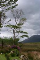 Photo by Joe Desbonnet.
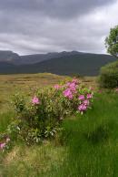 Photo by Joe Desbonnet.
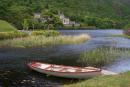 Photo by Joe Desbonnet.